Mystery Friday Foto #19 Solved: A Motor Parkway Aerial in Glen Oaks, Queens

Did you identify the Motor Parkway in Glen Oaks, Queens in this aerial?
Identify;
- The location and orientation of the aerial
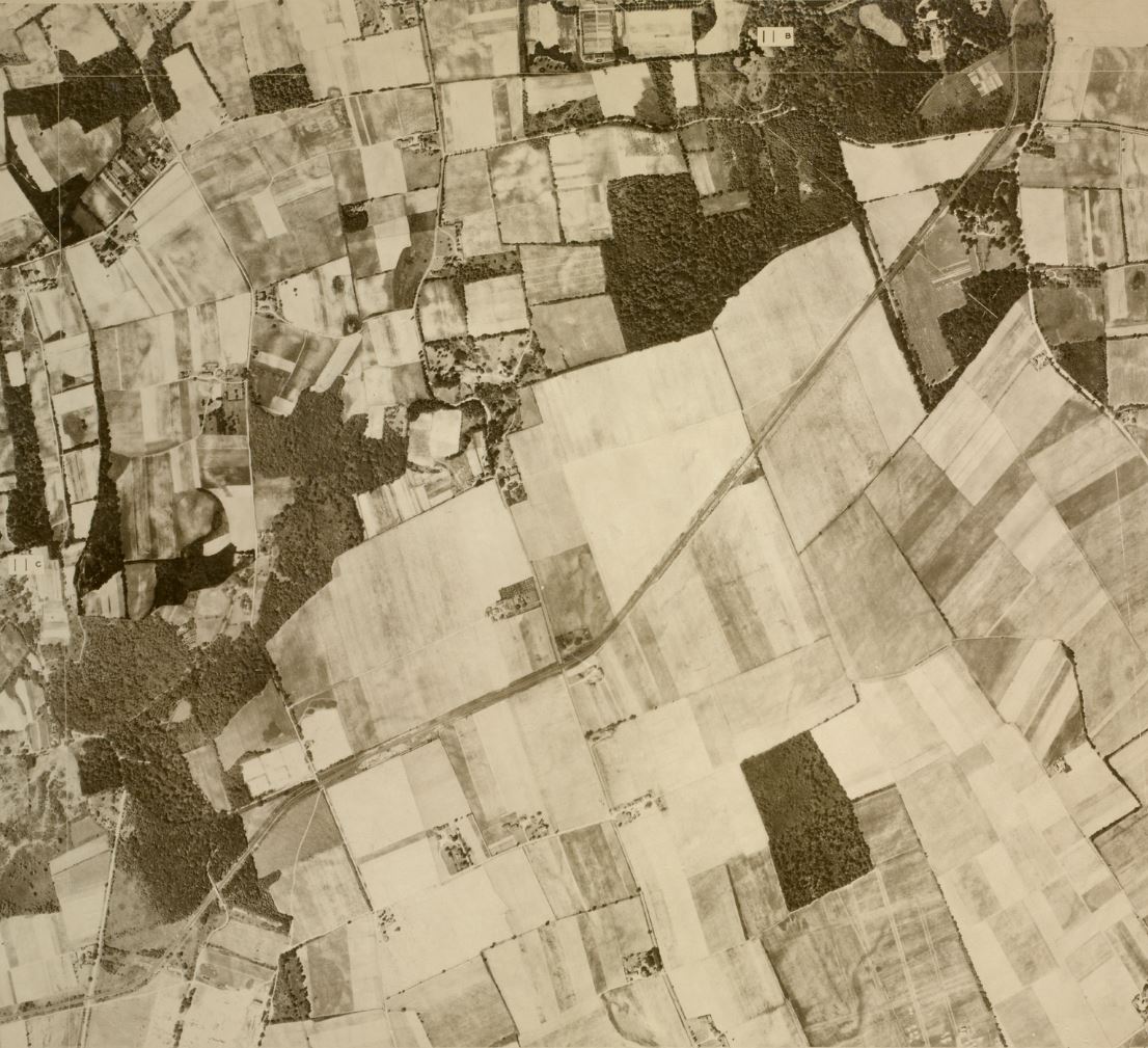
The Motor Parkway section through Glen Oaks, Queens. North facing up.
- The Motor Parkway and other major roads
The LIMP extends diagonally through the frame from the lower left to the upper right of the photo. Roads are detailed in the structure descriptions.
- Any structure linked to the Motor Parkway or Vanderbilt Cup Races
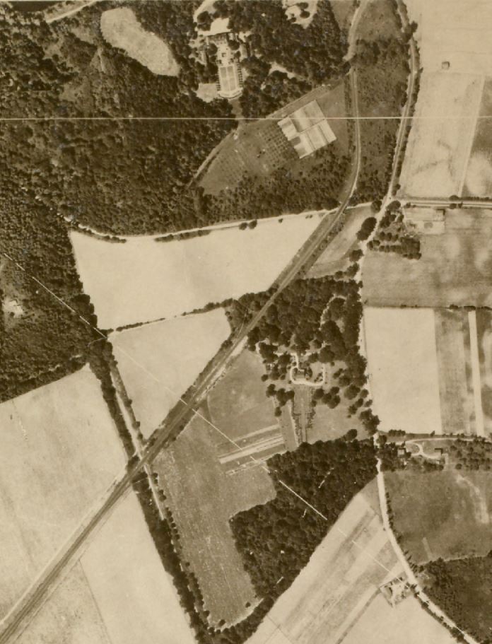
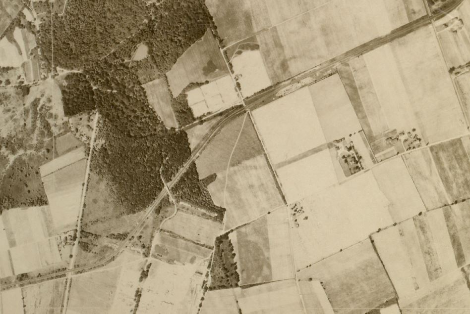
From lower left to upper right; Alley Road Bridge (Winchester Boulevard), Creedmoor Pedestrian Underpass, Clinton Avenue Bridge (Later called Commonwealth Blvd.), Little Neck Pkwy Bridge, Vanderbilt Farmway Bridge, Marcus Ave Bridge, William K. Vanderbilt's Deepdale estate, south Deepdale gate lodge.
- Approximate year
1924- From the NYPL Interactive 1924 Aerial Survey of New York City and the Motor Parkway in Queens & Lake Success
Comments (8)
Congrats to Dennis Spina, Joseph Oesterle, Steve Lucas, Eric C Shaffer, Alan Wunner, and Frank Femenias for identifying the Glen Oaks section of the Motor Parkway.
Kudos to Frank Femenias for the Jpeg documentation.
Greg O.
Closeups


Comments
This is a view of the Motor Pkwy. in what is now Glen Oaks, Queens. South is at the bottom, North at top, East to the right and West to the left. The Parkway is the major road starting in the lower left and going on the diagonal to the upper right. At the very top right is the Vanderbilt Deepdale Estate. Lakeville Rd. is also there, heading south and then east, out of the photo. Other roads crossing the Parkway starting from the West and heading East are Winchester Blvd., Commonwealth Blvd. and Little Neck Pkwy. You can make out a few parkway overpasses, especially the Creedmoor one in the lower left. Since there is almost no development in the area, I would guess that it is in the 1930s or earlier. I have attached present day map of the area which I believe was published by Frank Femenias with the help of many of our Vanderbiltcupraces.com contributors.
Lower left LIMP is coming out of Alley Pond Park. Crosses Winchester. Looks like the original steel bridge. Under the walkway in current Creedmore property. Then over Commonwealth Blvd and Little Neck Parkway. Top right we can see the parkway cross over Marcus Blvd and into what was Willie K’s property.
The photo is over today’s Glen Oaks / Lake Success area with north at the top. The LIMP runs from lower left to upper right with Winchester Blvd., Commonwealth Blvd., Little Neck Pkwy., Lakeville Road, and Marcus Ave. also visible. LIMP structures include bridges over most of the above roads with the exception of Lakeville Road (just out of frame). Also visible are the Creedmoor pedestrian bridge, Deepdale farmway bridge and possibly the Deepdale gate house. Since there appears to be no work being done on the proposed Union Tpke. extension and no evidence of 235th, 236th, or 237th streets, I think the date is around 1924.
Bottom left Winchester boulevard as the motor parkway moves northeast towards Lakeville Road and the lake success home of Vanderbilt. (Upper right of photo) In the middle of the photo is where Long Island Jewish Hospital now stands. Year is approximately 1925.
Judging from the curvature of the Parkway this appears to be the eastern Queens/western Nassau County segment between roughly Springfield Boulevard and Lakeville Road.Roads crossed would include Little Neck Parkway and Commonwealth Boulevard as well as Marcus Avenue. The area looks a bit different today.
I’m pretty sure it is Dix Hills, Suffolk County, but don’t know the date.
Glen Oaks, Queens County with north looking up. Queens County Farm Museum (1697 - ) in center. Photo is about 1926. Motor Pkwy is the jagged diagonal in the center. Pre Union Tpke, from l to r: Winchester Blvd (Alley Rd), LIMP Creedmoor Highway Bridge/Creedmoor RR Spur, Commonwealth Blvd (Clinton Ave), Little Neck Pkwy (Little Neck Rd), Lakeville Rd (Hyde Park Rd), Marcus Av. Willie K’s Deepdale Estate in the upper right corner.
Mid photo: Commonwealth Blvd 1942
Bottom photo: Little Neck Pkwy 1932
Top photo: Winchester Blvd bridge 1928.
Mid photo: Winchester Blvd bridges 1932.
Bottom photo: Creedmoor pedestrian bridge 1928.